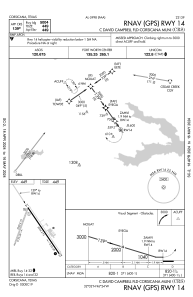
IAC chart of KCRS
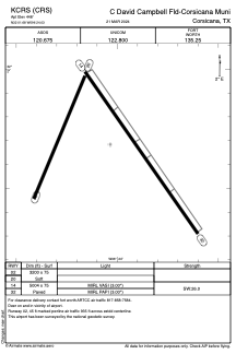
 ADC chart of KCRS
 Satellite view of KCRS
ADC chart of KCRS
Satellite view of KCRS
Sorry, we have no imagery here.
Sorry, we have no imagery here.
Sorry, we have no imagery here.
Sorry, we have no imagery here.
Sorry, we have no imagery here.
Sorry, we have no imagery here.


KCRS - C David Campbell Fld-Corsicana Muni
Located in Corsicana, United States
ICAO - CRS, IATA - CRS
Data provided by AirmateGeneral information
Coordinates: N32°1'41" W96°24'2"
Elevation is 448 feet MSL.
Magnetic variation is 06° East View others Airports in Texas
Operational data
Special qualification required
Current time UTC:
Current local time:
Weather
METAR: KCRS 020419Z AUTO 17014KT 10SM BKN028 24/19 A2960 RMK AO2 T02390194
Communications frequencies: [VIEW]
Runways:
| RWY identifier | QFU | Length (ft) | Width (ft) | Surface | LDA (ft) |
| 02 | 22° | 3200 | 75 | GRASS | |
| 20 | 202° | 3200 | 75 | GRASS | |
| 14 | 145° | 5004 | 75 | ASPH | |
| 32 | 325° | 5004 | 75 | ASPH |
Airport contact information
Address: Corsicana United States
Satellite view of KCRS
Sorry, we have no imagery here.
Sorry, we have no imagery here.
Sorry, we have no imagery here.
Sorry, we have no imagery here.
Sorry, we have no imagery here.
Sorry, we have no imagery here.