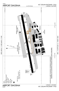
KCRQ - Mc Clellan-Palomar
Located in Carlsbad, United States
ICAO - CRQ, IATA - CLD
Data provided by AirmateGeneral information
Coordinates: N33°7'42" W117°16'48"
Elevation is 330 feet MSL.
Magnetic variation is 14° East View others Airports in California
Operational data
Special qualification required
Current time UTC:
Current local time:
Communications frequencies: [VIEW]
Runways:
| RWY identifier | QFU | Length (ft) | Width (ft) | Surface | LDA (ft) |
| 06 | 79° | 4897 | 150 | ASPH | 4600 |
| 24 | 259° | 4897 | 150 | ASPH | 4897 |
| H1 | 0° | 0 | 0 | UNK |
Airport contact information
Address: Carlsbad United States
Other aviation service providers
Repair station
Flight schools
Satellite view of KCRQ
Sorry, we have no imagery here.
Sorry, we have no imagery here.
Sorry, we have no imagery here.
Sorry, we have no imagery here.
Sorry, we have no imagery here.
Sorry, we have no imagery here.


