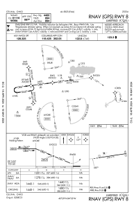
IAC chart of KCQA
 ADC chart of KCQA
 Satellite view of KCQA
ADC chart of KCQA
Satellite view of KCQA
Sorry, we have no imagery here.
Sorry, we have no imagery here.
Sorry, we have no imagery here.
Sorry, we have no imagery here.
Sorry, we have no imagery here.
Sorry, we have no imagery here.


KCQA - Lakefield
Located in Celina, United States
ICAO - CQA, IATA -
Data provided by AirmateGeneral information
Coordinates: N40°29'3" W84°33'29"
Elevation is 894 feet MSL.
Magnetic variation is -04° East View others Airports in Ohio
Operational data
Special qualification required
Current time UTC:
Current local time:
Weather at : KAXV - Neil Armstrong ( 22 km )
METAR: KAXV 061355Z AUTO 06012G15KT 10SM SCT017 BKN043 OVC085 03/00 A3004 RMK AO2
Communications frequencies: [VIEW]
Runways:
| RWY identifier | QFU | Length (ft) | Width (ft) | Surface | LDA (ft) |
| 08 | 83° | 4400 | 75 | ASPH | |
| 26 | 263° | 4400 | 75 | ASPH |
Airport contact information
Address: Celina United States
Satellite view of KCQA
Sorry, we have no imagery here.
Sorry, we have no imagery here.
Sorry, we have no imagery here.
Sorry, we have no imagery here.
Sorry, we have no imagery here.
Sorry, we have no imagery here.