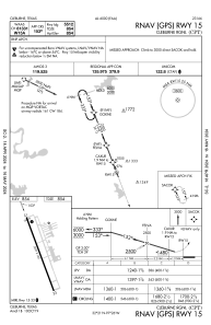
IAC chart of KCPT
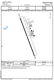
 ADC chart of KCPT
 Satellite view of KCPT
ADC chart of KCPT
Satellite view of KCPT
Sorry, we have no imagery here.
Sorry, we have no imagery here.
Sorry, we have no imagery here.
Sorry, we have no imagery here.
Sorry, we have no imagery here.
Sorry, we have no imagery here.


KCPT - Cleburne Rgnl
Located in Cleburne, United States
ICAO - CPT, IATA -
Data provided by AirmateGeneral information
Coordinates: N32°21'14" W97°26'2"
Elevation is 854 feet MSL.
Magnetic variation is 06° East View others Airports in Texas
Operational data
Special qualification required
Current time UTC:
Current local time:
Weather
METAR: KCPT 020735Z AUTO 16018G32KT 8SM OVC017 23/21 A2945 RMK AO2 PK WND 17032/0725 CIG 016V021 T02250206
Communications frequencies: [VIEW]
Runways:
| RWY identifier | QFU | Length (ft) | Width (ft) | Surface | LDA (ft) |
| 15 | 159° | 5697 | 100 | ASPH | |
| 33 | 339° | 5697 | 100 | ASPH |
Airport contact information
Address: Cleburne United States
Satellite view of KCPT
Sorry, we have no imagery here.
Sorry, we have no imagery here.
Sorry, we have no imagery here.
Sorry, we have no imagery here.
Sorry, we have no imagery here.
Sorry, we have no imagery here.