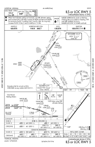
IAC chart of KCPK
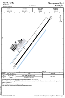
 ADC chart of KCPK
 Satellite view of KCPK
ADC chart of KCPK
Satellite view of KCPK
Sorry, we have no imagery here.
Sorry, we have no imagery here.
Sorry, we have no imagery here.
Sorry, we have no imagery here.
Sorry, we have no imagery here.
Sorry, we have no imagery here.


KCPK - Chesapeake Rgnl
Located in Norfolk, United States
ICAO - CPK, IATA -
Data provided by AirmateGeneral information
Coordinates: N36°39'56" W76°19'14"
Elevation is 18 feet MSL.
Magnetic variation is -11° East View others Airports in Virginia
Operational data
Special qualification required
Current time UTC:
Current local time:
Weather
METAR: KCPK 011355Z AUTO 33008KT 10SM OVC049 14/04 A2996 RMK AO2 LTG DSNT S T01350037
Communications frequencies: [VIEW]
Runways:
| RWY identifier | QFU | Length (ft) | Width (ft) | Surface | LDA (ft) |
| 05 | 36° | 5500 | 100 | ASPH | |
| 23 | 216° | 5500 | 100 | ASPH |
Airport contact information
Address: Norfolk United States
Other aviation service providers
Flight schools

Satellite view of KCPK
Sorry, we have no imagery here.
Sorry, we have no imagery here.
Sorry, we have no imagery here.
Sorry, we have no imagery here.
Sorry, we have no imagery here.
Sorry, we have no imagery here.