


KCOU - Columbia Rgnl
Located in Columbia, United States
ICAO - COU, IATA - COU
Data provided by AirmateGeneral information
Coordinates: N38°49'4" W92°13'4"
Elevation is 889 feet MSL.
Magnetic variation is 00° East View others Airports in Missouri
Operational data
Special qualification required
Current time UTC:
Current local time:
Weather
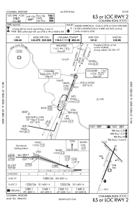
METAR: KCOU 191754Z 20015KT 10SM CLR 08/02 A3013 RMK AO2 PRESFR SLP207 I6000 T00780022 10078 21033 58033
TAF: KCOU 191726Z 1918/2018 22013G23KT P6SM FEW250 FM192300 25009KT P6SM FEW250 FM200300 30014G28KT P6SM FEW200 FM201300 33015G28KT P6SM SCT040
Communications frequencies: [VIEW]
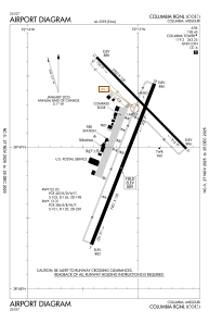
Runways:
| RWY identifier | QFU | Length (ft) | Width (ft) | Surface | LDA (ft) |
| 02 | 21° | 7401 | 150 | CONC | |
| 20 | 201° | 7401 | 150 | CONC | |
| 13 | 135° | 5500 | 100 | CONC | 5500 |
| 31 | 315° | 5500 | 100 | CONC | 5500 |
Airport contact information
Address: Columbia United States
Other aviation service providers
Repair station

Blackhawk Aerospace Technologies Inc.
Blackhawk Aerospace Technologies Inc.
conrad.theisen@blackhawk.aero309-314-4169