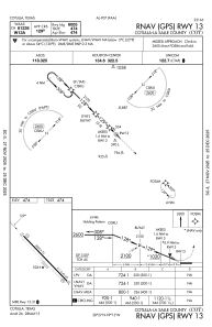
IAC chart of KCOT
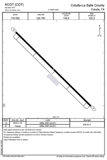
 ADC chart of KCOT
 Satellite view of KCOT
ADC chart of KCOT
Satellite view of KCOT
Sorry, we have no imagery here.
Sorry, we have no imagery here.
Sorry, we have no imagery here.
Sorry, we have no imagery here.
Sorry, we have no imagery here.
Sorry, we have no imagery here.


KCOT - Cotulla-La Salle County
Located in Cotulla, United States
ICAO - COT, IATA - COT
Data provided by AirmateGeneral information
Coordinates: N28°27'21" W99°13'2"
Elevation is 474 feet MSL.
Magnetic variation is 06° East View others Airports in Texas
Operational data
Special qualification required
Current time UTC:
Current local time:
Weather
METAR: KCOT 020253Z AUTO 16012G21KT 7SM CLR 28/21 A2953 RMK AO2 SLP991 T02830211 53016
TAF: KCOT 012321Z 0200/0224 16012G20KT P6SM BKN035 FM020300 14019G26KT P6SM SCT250 FM020600 15012G20KT P6SM BKN250 WS020/18045KT FM021200 VRB06KT P6SM FEW025 BKN250 TEMPO 0213/0217 BKN025
Communications frequencies: [VIEW]
Runways:
| RWY identifier | QFU | Length (ft) | Width (ft) | Surface | LDA (ft) |
| 13 | 134° | 6005 | 75 | ASPH | |
| 31 | 314° | 6005 | 75 | ASPH |
Airport contact information
Address: Cotulla United States
Satellite view of KCOT
Sorry, we have no imagery here.
Sorry, we have no imagery here.
Sorry, we have no imagery here.
Sorry, we have no imagery here.
Sorry, we have no imagery here.
Sorry, we have no imagery here.