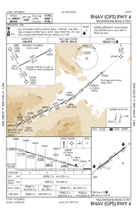
IAC chart of KCOD
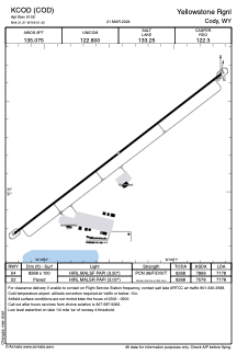
 ADC chart of KCOD
 Satellite view of KCOD
ADC chart of KCOD
Satellite view of KCOD
Sorry, we have no imagery here.
Sorry, we have no imagery here.
Sorry, we have no imagery here.
Sorry, we have no imagery here.
Sorry, we have no imagery here.
Sorry, we have no imagery here.


KCOD - Yellowstone Rgnl
Located in Cody, United States
ICAO - COD, IATA - COD
Data provided by AirmateGeneral information
Coordinates: N44°31'13" W109°1'26"
Elevation is 5102 feet MSL.
Magnetic variation is 11° East View others Airports in Wyoming
Operational data
Special qualification required
Current time UTC:
Current local time:
Weather
TAF: KCOD 070520Z 0706/0806 22005KT P6SM SKC FM070700 25010G18KT P6SM FEW250 FM071900 26014G22KT P6SM FEW200 FM080300 23008KT P6SM FEW100 SCT150
Communications frequencies: [VIEW]
Runways:
| RWY identifier | QFU | Length (ft) | Width (ft) | Surface | LDA (ft) |
| 04 | 52° | 8268 | 100 | ASPH | 7178 |
| 22 | 232° | 8268 | 100 | ASPH | 7178 |
Airport contact information
Address: Cody United States
Other aviation service providers
Flight schools

Satellite view of KCOD
Sorry, we have no imagery here.
Sorry, we have no imagery here.
Sorry, we have no imagery here.
Sorry, we have no imagery here.
Sorry, we have no imagery here.
Sorry, we have no imagery here.