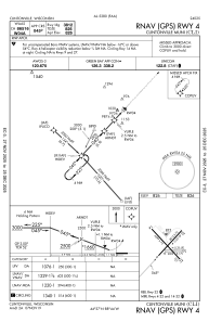
IAC chart of KCLI
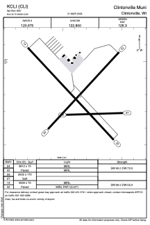
 ADC chart of KCLI
 Satellite view of KCLI
ADC chart of KCLI
Satellite view of KCLI
Sorry, we have no imagery here.
Sorry, we have no imagery here.
Sorry, we have no imagery here.
Sorry, we have no imagery here.
Sorry, we have no imagery here.
Sorry, we have no imagery here.


KCLI - Clintonville Muni
Located in Clintonville, United States
ICAO - CLI, IATA - CLI
Data provided by AirmateGeneral information
Coordinates: N44°36'47" W88°43'51"
Elevation is 825 feet MSL.
Magnetic variation is -02° East View others Airports in Wisconsin
Operational data
Special qualification required
Current time UTC:
Current local time:
Weather
METAR: KCLI 240535Z AUTO 00000KT 10SM CLR 05/04 A3019 RMK AO2 T00530038
Communications frequencies: [VIEW]
Runways:
| RWY identifier | QFU | Length (ft) | Width (ft) | Surface | LDA (ft) |
| 04 | 43° | 3812 | 75 | ASPH | |
| 22 | 223° | 3812 | 75 | ASPH | |
| 09 | 89° | 2002 | 170 | GRASS | |
| 27 | 268° | 2002 | 170 | GRASS | |
| 14 | 137° | 4599 | 75 | ASPH | |
| 32 | 317° | 4599 | 75 | ASPH |
Airport contact information
Address: Clintonville United States
Other aviation service providers
Repair station

Satellite view of KCLI
Sorry, we have no imagery here.
Sorry, we have no imagery here.
Sorry, we have no imagery here.
Sorry, we have no imagery here.
Sorry, we have no imagery here.
Sorry, we have no imagery here.