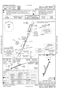
IAC chart of KCKB
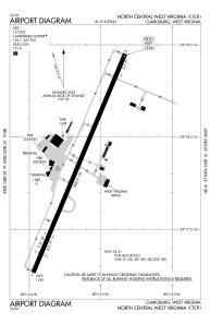
 ADC chart of KCKB
 Satellite view of KCKB
ADC chart of KCKB
Satellite view of KCKB
Sorry, we have no imagery here.
Sorry, we have no imagery here.
Sorry, we have no imagery here.
Sorry, we have no imagery here.
Sorry, we have no imagery here.
Sorry, we have no imagery here.


KCKB - North Central West Virginia
Located in Clarksburg, United States
ICAO - CKB, IATA - CKB
Data provided by AirmateGeneral information
Coordinates: N39°17'52" W80°13'39"
Elevation is 1223 feet MSL.
Magnetic variation is -08° East View others Airports in West Virginia
Operational data
Special qualification required
Current time UTC:
Current local time:
Weather
METAR: KCKB 021953Z 20017G30KT 10SM CLR 23/11 A2995 RMK AO2 PK WND 21031/1936 SLP133 T02280111
TAF: KCKB 021720Z 0218/0318 17012G25KT P6SM VCTS BKN070CB FM022000 18013G25KT P6SM SCT110 FM031000 20012G24KT P6SM -SHRA VCTS BKN060CB WS020/21055KT FM031300 21012G24KT P6SM OVC070 FM031700 23013G24KT 6SM -SHRA VCTS BKN040CB
Communications frequencies: [VIEW]
Runways:
| RWY identifier | QFU | Length (ft) | Width (ft) | Surface | LDA (ft) |
| 03 | 23° | 7800 | 150 | ASPH | 7130 |
| 21 | 203° | 7800 | 150 | ASPH | 7130 |
| H1 | 0° | 0 | 0 | UNK |
Airport contact information
Address: Clarksburg United States
Satellite view of KCKB
Sorry, we have no imagery here.
Sorry, we have no imagery here.
Sorry, we have no imagery here.
Sorry, we have no imagery here.
Sorry, we have no imagery here.
Sorry, we have no imagery here.