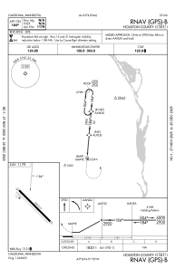
IAC chart of KCHU
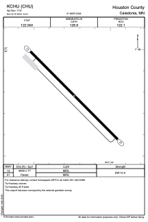
 ADC chart of KCHU
 Satellite view of KCHU
ADC chart of KCHU
Satellite view of KCHU
Sorry, we have no imagery here.
Sorry, we have no imagery here.
Sorry, we have no imagery here.
Sorry, we have no imagery here.
Sorry, we have no imagery here.
Sorry, we have no imagery here.


KCHU - Houston County
Located in Caledonia, United States
ICAO - CHU, IATA -
Data provided by AirmateGeneral information
Coordinates: N43°35'47" W91°30'14"
Elevation is 1179 feet MSL.
Magnetic variation is 01° East View others Airports in Minnesota
Operational data
Special qualification required
Current time UTC:
Current local time:
Weather at : KLSE - La Crosse Rgnl ( 37 km )
METAR: KLSE 022253Z 24008KT 7SM CLR 26/12 A3026 RMK AO2 SLP241 T02560122
TAF: KLSE 021738Z 0218/0318 18006KT 6SM FU FEW050 FM030100 15003KT 6SM FU SKC FM030900 15003KT 6SM FU BCFG SCT003 FM031300 17006KT P6SM FEW250
Communications frequencies: [VIEW]
Runways:
| RWY identifier | QFU | Length (ft) | Width (ft) | Surface | LDA (ft) |
| 13 | 135° | 3499 | 77 | ASPH | |
| 31 | 315° | 3499 | 77 | ASPH |
Airport contact information
Address: Caledonia United States
Satellite view of KCHU
Sorry, we have no imagery here.
Sorry, we have no imagery here.
Sorry, we have no imagery here.
Sorry, we have no imagery here.
Sorry, we have no imagery here.
Sorry, we have no imagery here.