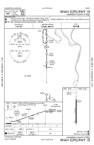
IAC chart of KCHQ
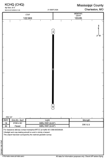
 ADC chart of KCHQ
 Satellite view of KCHQ
ADC chart of KCHQ
Satellite view of KCHQ
Sorry, we have no imagery here.
Sorry, we have no imagery here.
Sorry, we have no imagery here.
Sorry, we have no imagery here.
Sorry, we have no imagery here.
Sorry, we have no imagery here.


KCHQ - Mississippi County
Located in Charleston, United States
ICAO - CHQ, IATA -
Data provided by AirmateGeneral information
Coordinates: N36°50'32" W89°21'35"
Elevation is 313 feet MSL.
Magnetic variation is -02° East View others Airports in Missouri
Operational data
Special qualification required
Current time UTC:
Current local time:
Weather at : KSIK - Sikeston Meml Muni ( 19 km )
METAR: KSIK 050955Z AUTO 10005KT 5SM RA BR 18/18 A2992 RMK AO2 LTG DSNT N - SE AND SW P0002 T01790179 $
Communications frequencies: [VIEW]
Runways:
| RWY identifier | QFU | Length (ft) | Width (ft) | Surface | LDA (ft) |
| 18 | 180° | 3196 | 60 | ASPH | |
| 36 | 360° | 3196 | 60 | ASPH |
Airport contact information
Address: Charleston United States
Satellite view of KCHQ
Sorry, we have no imagery here.
Sorry, we have no imagery here.
Sorry, we have no imagery here.
Sorry, we have no imagery here.
Sorry, we have no imagery here.
Sorry, we have no imagery here.