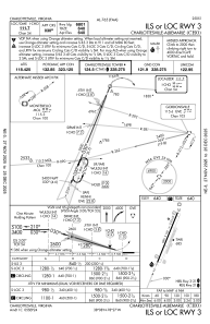
IAC chart of KCHO
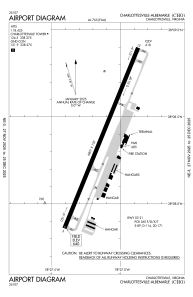
 ADC chart of KCHO
 Satellite view of KCHO
ADC chart of KCHO
Satellite view of KCHO
Sorry, we have no imagery here.
Sorry, we have no imagery here.
Sorry, we have no imagery here.
Sorry, we have no imagery here.
Sorry, we have no imagery here.
Sorry, we have no imagery here.


KCHO - Charlottesville-Albemarle
Located in Charlottesville, United States
ICAO - CHO, IATA - CHO
Data provided by AirmateGeneral information
Coordinates: N38°8'23" W78°27'8"
Elevation is 640 feet MSL.
Magnetic variation is -08° East View others Airports in Virginia
Operational data
Special qualification required
Current time UTC:
Current local time:
Weather
METAR: KCHO 011453Z VRB05KT 10SM CLR 12/01 A3004 RMK AO2 SLP168 T01170006 51031
TAF: KCHO 011300Z 0113/0212 32011G18KT P6SM SKC FM011700 19006KT P6SM SKC FM011900 14005KT P6SM SKC FM012100 06005KT P6SM FEW150
Communications frequencies: [VIEW]
Runways:
| RWY identifier | QFU | Length (ft) | Width (ft) | Surface | LDA (ft) |
| 03 | 22° | 6801 | 150 | ASPH | 6801 |
| 21 | 202° | 6801 | 150 | ASPH | 6801 |
Airport contact information
Address: Charlottesville United States
Other aviation service providers
Flight schools

Satellite view of KCHO
Sorry, we have no imagery here.
Sorry, we have no imagery here.
Sorry, we have no imagery here.
Sorry, we have no imagery here.
Sorry, we have no imagery here.
Sorry, we have no imagery here.