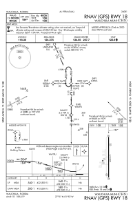
IAC chart of KCHN
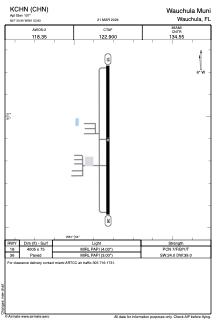
 ADC chart of KCHN
 Satellite view of KCHN
ADC chart of KCHN
Satellite view of KCHN
Sorry, we have no imagery here.
Sorry, we have no imagery here.
Sorry, we have no imagery here.
Sorry, we have no imagery here.
Sorry, we have no imagery here.
Sorry, we have no imagery here.


KCHN - Wauchula Muni
Located in Wauchula, United States
ICAO - CHN, IATA -
Data provided by AirmateGeneral information
Coordinates: N27°30'54" W81°52'50"
Elevation is 107 feet MSL.
Magnetic variation is -04° East View others Airports in Florida
Operational data
Special qualification required
Current time UTC:
Current local time:
Weather at : KBOW - Bartow Exec ( 49 km )
METAR: KBOW 051350Z 14014KT 10SM SCT019 SCT027 26/21 A3023
Communications frequencies: [VIEW]
Runways:
| RWY identifier | QFU | Length (ft) | Width (ft) | Surface | LDA (ft) |
| 18 | 180° | 4005 | 75 | ASPH | |
| 36 | 360° | 4005 | 75 | ASPH |
Airport contact information
Address: Wauchula United States
Satellite view of KCHN
Sorry, we have no imagery here.
Sorry, we have no imagery here.
Sorry, we have no imagery here.
Sorry, we have no imagery here.
Sorry, we have no imagery here.
Sorry, we have no imagery here.