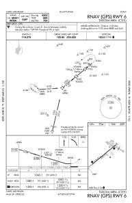
IAC chart of KCFS
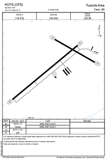
 ADC chart of KCFS
 Satellite view of KCFS
ADC chart of KCFS
Satellite view of KCFS
Sorry, we have no imagery here.
Sorry, we have no imagery here.
Sorry, we have no imagery here.
Sorry, we have no imagery here.
Sorry, we have no imagery here.
Sorry, we have no imagery here.


KCFS - Tuscola Area
Located in Caro, United States
ICAO - CFS, IATA -
Data provided by AirmateGeneral information
Coordinates: N43°27'32" W83°26'44"
Elevation is 704 feet MSL.
Magnetic variation is -08° East View others Airports in Michigan
Operational data
Special qualification required
Current time UTC:
Current local time:
Weather
METAR: KCFS 021935Z AUTO 13016G27KT 5SM -SN BKN008 BKN020 OVC035 02/01 A2981 RMK AO2 T00150013
Communications frequencies: [VIEW]
Runways:
| RWY identifier | QFU | Length (ft) | Width (ft) | Surface | LDA (ft) |
| 06 | 50° | 4302 | 75 | ASPH | |
| 24 | 230° | 4302 | 75 | ASPH | |
| 13 | 120° | 2277 | 110 | GRASS | |
| 31 | 300° | 2277 | 110 | GRASS |
Airport contact information
Address: Caro United States
Satellite view of KCFS
Sorry, we have no imagery here.
Sorry, we have no imagery here.
Sorry, we have no imagery here.
Sorry, we have no imagery here.
Sorry, we have no imagery here.
Sorry, we have no imagery here.