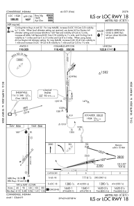
IAC chart of KCEV
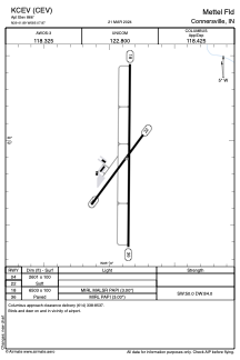
 ADC chart of KCEV
 Satellite view of KCEV
ADC chart of KCEV
Satellite view of KCEV
Sorry, we have no imagery here.
Sorry, we have no imagery here.
Sorry, we have no imagery here.
Sorry, we have no imagery here.
Sorry, we have no imagery here.
Sorry, we have no imagery here.


KCEV - Mettel Fld
Located in Connersville, United States
ICAO - CEV, IATA - CEV
Data provided by AirmateGeneral information
Coordinates: N39°41'53" W85°7'52"
Elevation is 866 feet MSL.
Magnetic variation is -04° East View others Airports in Indiana
Operational data
Special qualification required
Current time UTC:
Current local time:
Weather at : KRID - Richmond Muni ( 25 km )
METAR: KRID 050935Z AUTO 13009KT 7SM -RA OVC110 11/11 A2995 RMK AO2 P0012
Communications frequencies: [VIEW]
Runways:
| RWY identifier | QFU | Length (ft) | Width (ft) | Surface | LDA (ft) |
| 04 | 36° | 2601 | 100 | GRASS | |
| 22 | 216° | 2601 | 100 | GRASS | |
| 18 | 180° | 6503 | 100 | ASPH | |
| 36 | 360° | 6503 | 100 | ASPH |
Airport contact information
Address: Connersville United States
Satellite view of KCEV
Sorry, we have no imagery here.
Sorry, we have no imagery here.
Sorry, we have no imagery here.
Sorry, we have no imagery here.
Sorry, we have no imagery here.
Sorry, we have no imagery here.