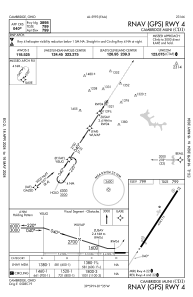
IAC chart of KCDI
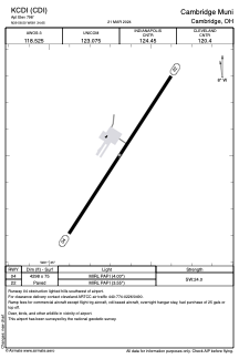
 ADC chart of KCDI
 Satellite view of KCDI
ADC chart of KCDI
Satellite view of KCDI
Sorry, we have no imagery here.
Sorry, we have no imagery here.
Sorry, we have no imagery here.
Sorry, we have no imagery here.
Sorry, we have no imagery here.
Sorry, we have no imagery here.


KCDI - Cambridge Muni
Located in Cambridge, United States
ICAO - CDI, IATA -
Data provided by AirmateGeneral information
Coordinates: N39°58'30" W81°34'39"
Elevation is 798 feet MSL.
Magnetic variation is -07° East View others Airports in Ohio
Operational data
Special qualification required
Current time UTC:
Current local time:
Weather
METAR: KCDI 080215Z AUTO 34006KT 310V010 10SM -RA BKN019 OVC025 03/00 A2985 RMK AO2 T00280001
Communications frequencies: [VIEW]
Runways:
| RWY identifier | QFU | Length (ft) | Width (ft) | Surface | LDA (ft) |
| 04 | 33° | 4298 | 75 | ASPH | |
| 22 | 213° | 4298 | 75 | ASPH |
Airport contact information
Address: Cambridge United States
Satellite view of KCDI
Sorry, we have no imagery here.
Sorry, we have no imagery here.
Sorry, we have no imagery here.
Sorry, we have no imagery here.
Sorry, we have no imagery here.
Sorry, we have no imagery here.