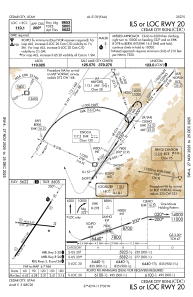
IAC chart of KCDC
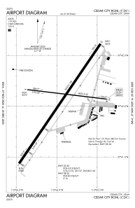
 ADC chart of KCDC
 Satellite view of KCDC
ADC chart of KCDC
Satellite view of KCDC
Sorry, we have no imagery here.
Sorry, we have no imagery here.
Sorry, we have no imagery here.
Sorry, we have no imagery here.
Sorry, we have no imagery here.
Sorry, we have no imagery here.


KCDC - Cedar City Rgnl
Located in Cedar City, United States
ICAO - CDC, IATA - CDC
Data provided by AirmateGeneral information
Coordinates: N37°42'3" W113°5'56"
Elevation is 5622 feet MSL.
Magnetic variation is 14° East View others Airports in Utah
Operational data
Special qualification required
Current time UTC:
Current local time:
Weather
METAR: KCDC 011053Z AUTO 31003KT 10SM FEW055 OVC075 03/M01 A2968 RMK AO2 SLP014 T00331011
Communications frequencies: [VIEW]
Runways:
| RWY identifier | QFU | Length (ft) | Width (ft) | Surface | LDA (ft) |
| 02 | 34° | 8653 | 150 | ASPH | 8653 |
| 20 | 214° | 8653 | 150 | ASPH | 8653 |
| 08 | 97° | 4822 | 60 | ASPH | 4822 |
| 26 | 277° | 4822 | 60 | ASPH | 4822 |
Airport contact information
Address: Cedar City United States
Other aviation service providers
Flight schools

Satellite view of KCDC
Sorry, we have no imagery here.
Sorry, we have no imagery here.
Sorry, we have no imagery here.
Sorry, we have no imagery here.
Sorry, we have no imagery here.
Sorry, we have no imagery here.