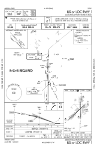
IAC chart of KCAK
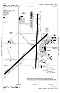
 ADC chart of KCAK
 Satellite view of KCAK
ADC chart of KCAK
Satellite view of KCAK
Sorry, we have no imagery here.
Sorry, we have no imagery here.
Sorry, we have no imagery here.
Sorry, we have no imagery here.
Sorry, we have no imagery here.
Sorry, we have no imagery here.


KCAK - Akron-Canton Rgnl
Located in Akron, United States
ICAO - CAK, IATA - CAK
Data provided by AirmateGeneral information
Coordinates: N40°54'54" W81°26'37"
Elevation is 1225 feet MSL.
Magnetic variation is -07° East View others Airports in Ohio
Operational data
Special qualification required
Current time UTC:
Current local time:
Weather
METAR: KCAK 081851Z 30007G17KT 10SM BKN044 00/M09 A3008 RMK AO2 SLP198 T00001089
TAF: KCAK 081725Z 0818/0918 32012G20KT P6SM BKN040 FM082000 31010G18KT P6SM SCT060 FM090200 VRB04KT P6SM BKN070 FM091600 23007KT P6SM BKN250
Communications frequencies: [VIEW]
Runways:
| RWY identifier | QFU | Length (ft) | Width (ft) | Surface | LDA (ft) |
| 01 | 2° | 7601 | 150 | ASPH | 7007 |
| 19 | 182° | 7601 | 150 | ASPH | 7007 |
| 05 | 47° | 8204 | 150 | ASPH | 8204 |
| 23 | 227° | 8204 | 150 | ASPH | 8204 |
Airport contact information
Address: Akron United States
Other aviation service providers
Flight schools

Satellite view of KCAK
Sorry, we have no imagery here.
Sorry, we have no imagery here.
Sorry, we have no imagery here.
Sorry, we have no imagery here.
Sorry, we have no imagery here.
Sorry, we have no imagery here.