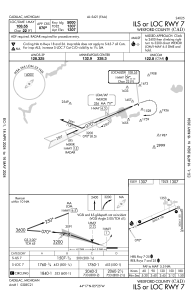
IAC chart of KCAD
 Satellite view of KCAD
Satellite view of KCAD
Sorry, we have no imagery here.
Sorry, we have no imagery here.
Sorry, we have no imagery here.
Sorry, we have no imagery here.
Sorry, we have no imagery here.
Sorry, we have no imagery here.


KCAD - Wexford County
Located in Cadillac, United States
ICAO - CAD, IATA - CAD
Data provided by AirmateGeneral information
Coordinates: N44°16'31" W85°25'8"
Elevation is 1306 feet MSL.
Magnetic variation is -04° East View others Airports in Michigan
Operational data
Special qualification required
Current time UTC:
Current local time:
Weather
METAR: KCAD 022135Z AUTO 13016KT 10SM OVC006 02/01 A2953 RMK AO2 PK WND 13027/59 PRESFR
Communications frequencies: [VIEW]
Runways:
| RWY identifier | QFU | Length (ft) | Width (ft) | Surface | LDA (ft) |
| 07 | 66° | 5001 | 100 | ASPH | |
| 25 | 246° | 5001 | 100 | ASPH | |
| 18 | 179° | 1986 | 150 | GRASS | |
| 36 | 359° | 1986 | 150 | GRASS |
Airport contact information
Address: Cadillac United States
Other aviation service providers
Flight schools

Satellite view of KCAD
Sorry, we have no imagery here.
Sorry, we have no imagery here.
Sorry, we have no imagery here.
Sorry, we have no imagery here.
Sorry, we have no imagery here.
Sorry, we have no imagery here.