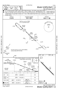
IAC chart of KBYY
 ADC chart of KBYY
 Satellite view of KBYY
ADC chart of KBYY
Satellite view of KBYY
Sorry, we have no imagery here.
Sorry, we have no imagery here.
Sorry, we have no imagery here.
Sorry, we have no imagery here.
Sorry, we have no imagery here.
Sorry, we have no imagery here.


KBYY - Bay City Rgnl
Located in Bay City, United States
ICAO - BYY, IATA - BBC
Data provided by AirmateGeneral information
Coordinates: N28°58'24" W95°51'48"
Elevation is 44 feet MSL.
Magnetic variation is 03° East View others Airports in Texas
Operational data
Special qualification required
Current time UTC:
Current local time:
Weather
METAR: KBYY 021335Z AUTO 14016G20KT 10SM CLR 24/24 A2959 RMK AO2 T02390235
Communications frequencies: [VIEW]
Runways:
| RWY identifier | QFU | Length (ft) | Width (ft) | Surface | LDA (ft) |
| 13 | 134° | 5107 | 75 | ASPH | |
| 31 | 314° | 5107 | 75 | ASPH |
Airport contact information
Address: Bay City United States
Satellite view of KBYY
Sorry, we have no imagery here.
Sorry, we have no imagery here.
Sorry, we have no imagery here.
Sorry, we have no imagery here.
Sorry, we have no imagery here.
Sorry, we have no imagery here.