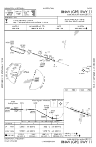
IAC chart of KBUU
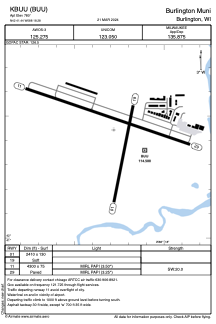
 ADC chart of KBUU
 Satellite view of KBUU
ADC chart of KBUU
Satellite view of KBUU
Sorry, we have no imagery here.
Sorry, we have no imagery here.
Sorry, we have no imagery here.
Sorry, we have no imagery here.
Sorry, we have no imagery here.
Sorry, we have no imagery here.


KBUU - Burlington Muni
Located in Burlington, United States
ICAO - BUU, IATA -
Data provided by AirmateGeneral information
Coordinates: N42°41'27" W88°18'17"
Elevation is 780 feet MSL.
Magnetic variation is -03° East View others Airports in Wisconsin
Operational data
Special qualification required
Current time UTC:
Current local time:
Weather
METAR: KBUU 301635Z AUTO 25006KT 10SM BKN100 BKN120 20/11 A2982 RMK AO2 T01960110 PWINO
Communications frequencies: [VIEW]
Runways:
| RWY identifier | QFU | Length (ft) | Width (ft) | Surface | LDA (ft) |
| 01 | 12° | 2410 | 130 | GRASS | |
| 19 | 192° | 2410 | 130 | GRASS | |
| 11 | 109° | 4300 | 75 | ASPH | |
| 29 | 289° | 4300 | 75 | ASPH |
Airport contact information
Address: Burlington United States
Other aviation service providers
Repair station

Satellite view of KBUU
Sorry, we have no imagery here.
Sorry, we have no imagery here.
Sorry, we have no imagery here.
Sorry, we have no imagery here.
Sorry, we have no imagery here.
Sorry, we have no imagery here.