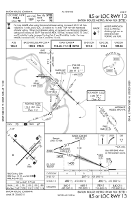
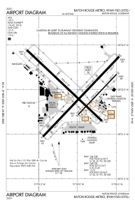
KBTR - Baton Rouge Metro, Ryan Fld
Located in Baton Rouge, United States
ICAO - BTR, IATA - BTR
Data provided by AirmateGeneral information
Coordinates: N30°31'59" W91°8'60"
Elevation is 69 feet MSL.
Magnetic variation is 00° East View others Airports in Louisiana
Operational data
Special qualification required
Current time UTC:
Current local time:
Weather
TAF: KBTR 060527Z 0606/0706 18011G20KT 5SM -SHRA BR BKN015 OVC025 TEMPO 0606/0609 1SM TSRA BR OVC010CB FM060900 20010G18KT P6SM -SHRA OVC015 TEMPO 0609/0612 1SM TSRA BR OVC008CB FM061200 28010KT 5SM -SHRA BR BKN008 OVC020 FM061500 31010KT 5SM BR BKN008 OVC020 PROB30 0615/0616 2SM SHRA BR OVC005 FM061900 31010KT P6SM BKN015 OVC030
Communications frequencies: [VIEW]
Runways:
| RWY identifier | QFU | Length (ft) | Width (ft) | Surface | LDA (ft) |
| 04L | 43° | 7500 | 150 | CONC | 7500 |
| 22R | 223° | 7500 | 150 | CONC | 7500 |
| 04R | 43° | 3799 | 75 | ASPH | 3799 |
| 22L | 223° | 3799 | 75 | ASPH | 3799 |
| 13 | 133° | 7005 | 150 | ASPH | 5720 |
| 31 | 313° | 7005 | 150 | ASPH | 6094 |
Airport contact information
Address: Baton Rouge United States
Other aviation service providers
Repair station
Flight schools
Satellite view of KBTR
Sorry, we have no imagery here.
Sorry, we have no imagery here.
Sorry, we have no imagery here.
Sorry, we have no imagery here.
Sorry, we have no imagery here.
Sorry, we have no imagery here.


