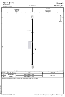
ADC chart of KBTF
 Satellite view of KBTF
Satellite view of KBTF
Sorry, we have no imagery here.
Sorry, we have no imagery here.
Sorry, we have no imagery here.
Sorry, we have no imagery here.
Sorry, we have no imagery here.
Sorry, we have no imagery here.


KBTF - Skypark
Located in Bountiful, United States
ICAO - BTF, IATA - BTF
Data provided by AirmateGeneral information
Coordinates: N40°52'5" W111°55'39"
Elevation is 4237 feet MSL.
Magnetic variation is 15° East View others Airports in Utah
Operational data
Special qualification required
Current time UTC:
Current local time:
Weather at : KSLC - Salt Lake City Intl ( 10 km )
METAR: KSLC 280654Z 15009KT 10SM CLR 24/M04 A3006 RMK AO2 SLP116 T02391044 403500200 $
TAF: KSLC 280523Z 2806/2912 15007KT P6SM SKC FM281700 17011G18KT P6SM SKC FM282200 30010KT P6SM SKC FM290300 14007KT P6SM SCT180
Communications frequencies: [VIEW]
Runways:
| RWY identifier | QFU | Length (ft) | Width (ft) | Surface | LDA (ft) |
| 17 | 0° | 4634 | 70 | ASPH | |
| 35 | 0° | 4634 | 70 | ASPH |
Airport contact information
Address: Bountiful United States
Other aviation service providers
Flight schools

Satellite view of KBTF
Sorry, we have no imagery here.
Sorry, we have no imagery here.
Sorry, we have no imagery here.
Sorry, we have no imagery here.
Sorry, we have no imagery here.
Sorry, we have no imagery here.