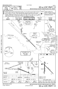
IAC chart of KBRO
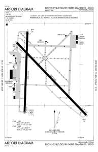
 ADC chart of KBRO
 Satellite view of KBRO
ADC chart of KBRO
Satellite view of KBRO
Sorry, we have no imagery here.
Sorry, we have no imagery here.
Sorry, we have no imagery here.
Sorry, we have no imagery here.
Sorry, we have no imagery here.
Sorry, we have no imagery here.


KBRO - Brownsville/South Padre Island Intl
Located in Brownsville, United States
ICAO - BRO, IATA - BRO
Data provided by AirmateGeneral information
Coordinates: N25°54'22" W97°25'34"
Elevation is 22 feet MSL.
Magnetic variation is 03° East View others Airports in Texas
Operational data
Special qualification required
Current time UTC:
Current local time:
Weather
METAR: KBRO 021353Z 17020G28KT 10SM CLR 27/22 A2957 RMK AO2 PK WND 16031/1330 SLP011 T02720222
TAF: KBRO 021120Z 0212/0312 17020G30KT P6SM FEW015 SCT035 WS020/18050KT FM021600 17022G32KT P6SM FEW025 SCT040 FM030100 15016G26KT P6SM BKN025
Communications frequencies: [VIEW]
Runways:
| RWY identifier | QFU | Length (ft) | Width (ft) | Surface | LDA (ft) |
| 13 | 135° | 7399 | 150 | ASPH | 7399 |
| 31 | 315° | 7399 | 150 | ASPH | 7399 |
| 18 | 182° | 6000 | 150 | ASPH | 5810 |
| 36 | 2° | 6000 | 150 | ASPH | 5532 |
Airport contact information
Address: Brownsville United States
Other aviation service providers
Flight schools

Satellite view of KBRO
Sorry, we have no imagery here.
Sorry, we have no imagery here.
Sorry, we have no imagery here.
Sorry, we have no imagery here.
Sorry, we have no imagery here.
Sorry, we have no imagery here.