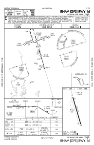
IAC chart of KBQP
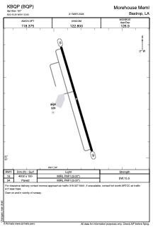
 ADC chart of KBQP
 Satellite view of KBQP
ADC chart of KBQP
Satellite view of KBQP
Sorry, we have no imagery here.
Sorry, we have no imagery here.
Sorry, we have no imagery here.
Sorry, we have no imagery here.
Sorry, we have no imagery here.
Sorry, we have no imagery here.


KBQP - Morehouse Meml
Located in Bastrop, United States
ICAO - BQP, IATA -
Data provided by AirmateGeneral information
Coordinates: N32°45'22" W91°52'50"
Elevation is 167 feet MSL.
Magnetic variation is 03° East View others Airports in Louisiana
Operational data
Special qualification required
Current time UTC:
Current local time:
Weather
METAR: KBQP 060855Z AUTO 32005KT 7SM BKN006 OVC014 10/10 A2992 RMK AO2 P0001 60001 T01030095
Communications frequencies: [VIEW]
Runways:
| RWY identifier | QFU | Length (ft) | Width (ft) | Surface | LDA (ft) |
| 16 | 164° | 4002 | 100 | ASPH | |
| 34 | 344° | 4002 | 100 | ASPH |
Airport contact information
Address: Bastrop United States
Other aviation service providers
Flight schools

Satellite view of KBQP
Sorry, we have no imagery here.
Sorry, we have no imagery here.
Sorry, we have no imagery here.
Sorry, we have no imagery here.
Sorry, we have no imagery here.
Sorry, we have no imagery here.