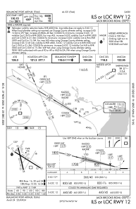
IAC chart of KBPT
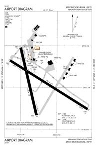
 ADC chart of KBPT
 Satellite view of KBPT
ADC chart of KBPT
Satellite view of KBPT
Sorry, we have no imagery here.
Sorry, we have no imagery here.
Sorry, we have no imagery here.
Sorry, we have no imagery here.
Sorry, we have no imagery here.


KBPT - Jack Brooks Rgnl
Located in Beaumont/Port Arthur, United States
ICAO - BPT, IATA - BPT
Data provided by AirmateGeneral information
Coordinates: N29°57'3" W94°1'15"
Elevation is 14 feet MSL.
Magnetic variation is 01° East View others Airports in Texas
Operational data
Special qualification required
Current time UTC:
Current local time:
Weather
METAR: KBPT 012053Z 17014KT 10SM OVC010 26/23 A2974 RMK AO2 SLP071 60000 T02610228 57022
TAF: KBPT 011947Z 0120/0218 14012KT P6SM BKN006 FM020300 16017G24KT 4SM BR BKN006 FM021500 17024G32KT P6SM BKN015
Communications frequencies: [VIEW]
Runways:
| RWY identifier | QFU | Length (ft) | Width (ft) | Surface | LDA (ft) |
| 12 | 121° | 6751 | 150 | CONC | 6508 |
| 30 | 301° | 6751 | 150 | CONC | 6751 |
| 16 | 166° | 5071 | 150 | OTHER | 5070 |
| 34 | 346° | 5071 | 150 | OTHER | 5070 |
Airport contact information
Address: Beaumont/Port Arthur United States
Other aviation service providers
Flight schools

Satellite view of KBPT
Sorry, we have no imagery here.
Sorry, we have no imagery here.
Sorry, we have no imagery here.
Sorry, we have no imagery here.
Sorry, we have no imagery here.