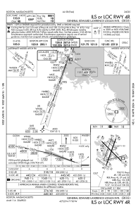
IAC chart of KBOS
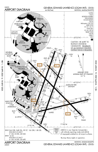
 ADC chart of KBOS
 Satellite view of KBOS
ADC chart of KBOS
Satellite view of KBOS
Sorry, we have no imagery here.
Sorry, we have no imagery here.
Sorry, we have no imagery here.
Sorry, we have no imagery here.
Sorry, we have no imagery here.
Sorry, we have no imagery here.


KBOS - General Edward Lawrence Logan Intl
Located in Boston, United States
ICAO - BOS, IATA - BOS
Data provided by AirmateGeneral information
Coordinates: N42°21'47" W71°0'23"
Elevation is 19 feet MSL.
Magnetic variation is -15° East View others Airports in Massachusetts
Operational data
Special qualification required
Current time UTC:
Current local time:
Weather
METAR: KBOS 312054Z 20011KT 10SM SCT009 OVC012 15/13 A2965 RMK AO2 SLP039 T01500128 55010
TAF: KBOS 312106Z 3121/0124 21011G20KT P6SM SCT009 OVC015 FM312300 20012G24KT 6SM BR VCSH OVC008 WS020/23040KT FM010300 21011G23KT 2SM +SHRA OVC005 WS020/24040KT FM010700 27012G21KT 5SM -SHRA OVC008 FM010900 30011G21KT P6SM BKN008 PROB30 0109/0111 4SM -SHRA OVC006 FM011400 32015G25KT P6SM SCT200
Communications frequencies: [VIEW]
Runways:
| RWY identifier | QFU | Length (ft) | Width (ft) | Surface | LDA (ft) |
| 04L | 20° | 7864 | 150 | ASPH | 7864 |
| 22R | 200° | 7864 | 150 | ASPH | 7046 |
| 04R | 20° | 10006 | 150 | ASPH | 8851 |
| 22L | 200° | 10006 | 150 | ASPH | 8806 |
| 09 | 77° | 7001 | 150 | ASPH | 7001 |
| 27 | 257° | 7001 | 150 | ASPH | 7001 |
| 14 | 125° | 5000 | 100 | ASPH | 5000 |
| 32 | 305° | 5000 | 100 | ASPH | 5000 |
| 15L | 135° | 2557 | 100 | ASPH | 2557 |
| 33R | 315° | 2557 | 100 | ASPH | 2557 |
| 15R | 135° | 10083 | 150 | ASPH | 9202 |
| 33L | 315° | 10083 | 150 | ASPH | 10083 |
Airport contact information
Address: Boston United States
Satellite view of KBOS
Sorry, we have no imagery here.
Sorry, we have no imagery here.
Sorry, we have no imagery here.
Sorry, we have no imagery here.
Sorry, we have no imagery here.
Sorry, we have no imagery here.