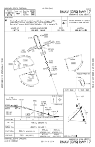
IAC chart of KBNL
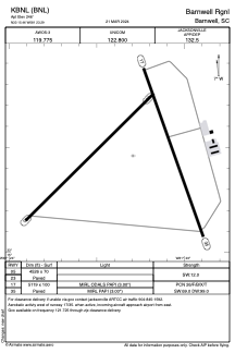
 ADC chart of KBNL
 Satellite view of KBNL
ADC chart of KBNL
Satellite view of KBNL
Sorry, we have no imagery here.
Sorry, we have no imagery here.
Sorry, we have no imagery here.
Sorry, we have no imagery here.
Sorry, we have no imagery here.
Sorry, we have no imagery here.


KBNL - Barnwell Rgnl
Located in Barnwell, United States
ICAO - BNL, IATA - BNL
Data provided by AirmateGeneral information
Coordinates: N33°15'28" W81°23'18"
Elevation is 246 feet MSL.
Magnetic variation is -05° East View others Airports in South Carolina
Operational data
Special qualification required
Current time UTC:
Current local time:
Weather
METAR: KBNL 050455Z AUTO 17003KT 10SM 21/19 A3023 RMK AO2
Communications frequencies: [VIEW]
Runways:
| RWY identifier | QFU | Length (ft) | Width (ft) | Surface | LDA (ft) |
| 05 | 45° | 4526 | 70 | ASPH | |
| 23 | 225° | 4526 | 70 | ASPH | |
| 17 | 160° | 5119 | 100 | ASPH | |
| 35 | 340° | 5119 | 100 | ASPH |
Airport contact information
Address: Barnwell United States
Satellite view of KBNL
Sorry, we have no imagery here.
Sorry, we have no imagery here.
Sorry, we have no imagery here.
Sorry, we have no imagery here.
Sorry, we have no imagery here.
Sorry, we have no imagery here.