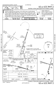
IAC chart of KBMI
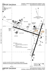
 ADC chart of KBMI
 Satellite view of KBMI
ADC chart of KBMI
Satellite view of KBMI
Sorry, we have no imagery here.
Sorry, we have no imagery here.
Sorry, we have no imagery here.
Sorry, we have no imagery here.
Sorry, we have no imagery here.
Sorry, we have no imagery here.


KBMI - Central Il Rgnl/Bloomington-Normal
Located in Bloomington/Normal, United States
ICAO - BMI, IATA - BMI
Data provided by AirmateGeneral information
Coordinates: N40°28'38" W88°54'57"
Elevation is 871 feet MSL.
Magnetic variation is -03° East View others Airports in Illinois
Operational data
Special qualification required
Current time UTC:
Current local time:
Weather
METAR: KBMI 061156Z 36012KT 10SM OVC110 02/M04 A3011 RMK AO2 SLP198 70002 T00221039 10056 20022 50001
TAF: KBMI 061120Z 0612/0712 01012KT P6SM BKN120 FM062200 VRB05KT P6SM BKN180 FM070500 23008KT P6SM SKC
Communications frequencies: [VIEW]
Runways:
| RWY identifier | QFU | Length (ft) | Width (ft) | Surface | LDA (ft) |
| 02 | 18° | 8000 | 150 | CONC | 8000 |
| 20 | 198° | 8000 | 150 | CONC | 8000 |
| 11 | 107° | 6525 | 150 | OTHER | 6525 |
| 29 | 287° | 6525 | 150 | OTHER | 6525 |
Airport contact information
Address: Bloomington/Normal United States
Other aviation service providers
Flight schools

Satellite view of KBMI
Sorry, we have no imagery here.
Sorry, we have no imagery here.
Sorry, we have no imagery here.
Sorry, we have no imagery here.
Sorry, we have no imagery here.
Sorry, we have no imagery here.