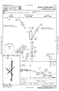
IAC chart of KBKD
 ADC chart of KBKD
 Satellite view of KBKD
ADC chart of KBKD
Satellite view of KBKD
Sorry, we have no imagery here.
Sorry, we have no imagery here.
Sorry, we have no imagery here.
Sorry, we have no imagery here.
Sorry, we have no imagery here.
Sorry, we have no imagery here.


KBKD - Stephens County
Located in Breckenridge, United States
ICAO - BKD, IATA - BKD
Data provided by AirmateGeneral information
Coordinates: N32°43'8" W98°53'30"
Elevation is 1284 feet MSL.
Magnetic variation is 07° East View others Airports in Texas
Operational data
Special qualification required
Current time UTC:
Current local time:
Weather
METAR: KBKD 012215Z AUTO 20019G26KT 10SM CLR 33/13 A2945 RMK AO2 T03320126
Communications frequencies: [VIEW]
Runways:
| RWY identifier | QFU | Length (ft) | Width (ft) | Surface | LDA (ft) |
| 04 | 45° | 2398 | 50 | ASPH | |
| 22 | 225° | 2398 | 50 | ASPH | |
| 13 | 135° | 2401 | 50 | ASPH | |
| 31 | 315° | 2401 | 50 | ASPH | |
| 17 | 180° | 5002 | 100 | ASPH | |
| 35 | 360° | 5002 | 100 | ASPH |
Airport contact information
Address: Breckenridge United States
Satellite view of KBKD
Sorry, we have no imagery here.
Sorry, we have no imagery here.
Sorry, we have no imagery here.
Sorry, we have no imagery here.
Sorry, we have no imagery here.
Sorry, we have no imagery here.