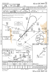
IAC chart of KBIF
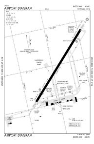
 ADC chart of KBIF
 Satellite view of KBIF
ADC chart of KBIF
Satellite view of KBIF
Sorry, we have no imagery here.
Sorry, we have no imagery here.
Sorry, we have no imagery here.
Sorry, we have no imagery here.
Sorry, we have no imagery here.
Sorry, we have no imagery here.


KBIF - Biggs Aaf (Fort Bliss)
Located in Fort Bliss/El Paso/, United States
ICAO - BIF, IATA - BIF
Data provided by AirmateGeneral information
Coordinates: N31°50'58" W106°22'48"
Elevation is 3946 feet MSL.
Magnetic variation is 08° East View others Airports in Texas
Operational data
Special qualification required
Current time UTC:
Current local time:
Weather
METAR: KBIF 021355Z AUTO 11003KT 9SM CLR 09/M06 A2973 RMK AO2 SLP019 T00901064 $
TAF: TAF KBIF 020800Z 0211/0317 27009KT 9999 SKC QNH2971INS BECMG 0218/0219 27015G30KT 4800 BLDU FEW100 560009 560909 QNH2967INS BECMG 0221/0222 26025G40KT 1600 BLDU SCT100 BKN150 560009 560909 QNH2967INS BECMG 0302/0304 26020G30KT 4800 BLDU FEW100 SCT150 540009 540909 QNH2969INS BECMG 0305/0307 25015G25KT 4800 BLDU FEW075 530009 530909 QNH2975INS BECMG 0307/0308 26009KT 9999 NSW FEW 530009 530909 QNH2969INS TX19/0221Z TN09/0313Z
Communications frequencies: [VIEW]
Runways:
| RWY identifier | QFU | Length (ft) | Width (ft) | Surface | LDA (ft) |
| 04 | 44° | 13554 | 150 | CONC | |
| 22 | 224° | 13554 | 150 | CONC |
Airport contact information
Address: Fort Bliss/El Paso/ United States
Satellite view of KBIF
Sorry, we have no imagery here.
Sorry, we have no imagery here.
Sorry, we have no imagery here.
Sorry, we have no imagery here.
Sorry, we have no imagery here.
Sorry, we have no imagery here.