IAC chart of KBGM
 ADC chart of KBGM
 Satellite view of KBGM

ADC chart of KBGM
Satellite view of KBGM
Sorry, we have no imagery here.
Sorry, we have no imagery here.
Sorry, we have no imagery here.
Sorry, we have no imagery here.
Sorry, we have no imagery here.
Sorry, we have no imagery here.


KBGM - Greater Binghamton/Edwin A Link Fld
Located in Binghamton, United States
ICAO - BGM, IATA - BGM
Data provided by AirmateGeneral information
Coordinates: N42°12'30" W75°58'47"
Elevation is 1635 feet MSL.
Magnetic variation is -12° East View others Airports in New York
Operational data
Special qualification required
Current time UTC:
Current local time:
Weather
METAR: KBGM 062253Z AUTO 32005KT 10SM OVC065 03/M05 A2989 RMK AO2 SLP134 T00331050
TAF: KBGM 062320Z 0700/0724 32005KT P6SM BKN045 FM070700 36004KT 5SM -SHSN BR OVC025 TEMPO 0708/0712 2SM -SHSN BR FM071200 15004KT 5SM -SHSN BR BKN025 FM071600 18005KT P6SM BKN035
Communications frequencies: [VIEW]
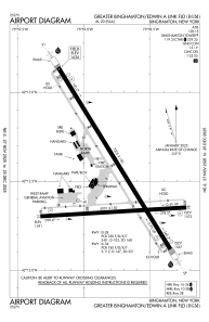
Runways:
| RWY identifier | QFU | Length (ft) | Width (ft) | Surface | LDA (ft) |
| 10 | 86° | 5001 | 150 | ASPH | 5001 |
| 28 | 266° | 5001 | 150 | ASPH | 5001 |
| 16 | 148° | 7305 | 150 | ASPH | 6905 |
| 34 | 328° | 7305 | 150 | ASPH | 7100 |
| H1 | 0° | 0 | 0 | UNK |
Airport contact information
Address: Binghamton United States
Other aviation service providers
Flight schools

Goodrich Pilot Training Center
Goodrich Pilot Training Center
doug@goodrichaviation.com+1(607)821-2982
Satellite view of KBGM
Sorry, we have no imagery here.
Sorry, we have no imagery here.
Sorry, we have no imagery here.
Sorry, we have no imagery here.
Sorry, we have no imagery here.
Sorry, we have no imagery here.