IAC chart of KBEA
 ADC chart of KBEA
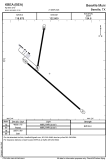
 Satellite view of KBEA
ADC chart of KBEA
Satellite view of KBEA
Sorry, we have no imagery here.
Sorry, we have no imagery here.
Sorry, we have no imagery here.
Sorry, we have no imagery here.
Sorry, we have no imagery here.
Sorry, we have no imagery here.


KBEA - Beeville Muni
Located in Beeville, United States
ICAO - BEA, IATA -
Data provided by AirmateGeneral information
Coordinates: N28°21'51" W97°47'31"
Elevation is 272 feet MSL.
Magnetic variation is 04° East View others Airports in Texas
Operational data
Special qualification required
Current time UTC:
Current local time:
Weather
METAR: KBEA 021315Z AUTO 16012G19KT 10SM OVC012 23/21 A2953 RMK AO2 T02330210 PWINO
Communications frequencies: [VIEW]
Runways:
| RWY identifier | QFU | Length (ft) | Width (ft) | Surface | LDA (ft) |
| 12 | 131° | 4553 | 75 | ASPH | |
| 30 | 311° | 4553 | 75 | ASPH | |
| 18 | 189° | 2251 | 60 | GRASS | |
| 36 | 9° | 2251 | 60 | GRASS |
Airport contact information
Address: Beeville United States
Satellite view of KBEA
Sorry, we have no imagery here.
Sorry, we have no imagery here.
Sorry, we have no imagery here.
Sorry, we have no imagery here.
Sorry, we have no imagery here.
Sorry, we have no imagery here.