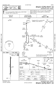
IAC chart of KBDG
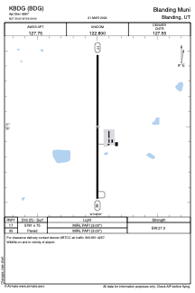
 ADC chart of KBDG
 Satellite view of KBDG
ADC chart of KBDG
Satellite view of KBDG
Sorry, we have no imagery here.
Sorry, we have no imagery here.
Sorry, we have no imagery here.
Sorry, we have no imagery here.
Sorry, we have no imagery here.
Sorry, we have no imagery here.


KBDG - Blanding Muni
Located in Blanding, United States
ICAO - BDG, IATA - BDG
Data provided by AirmateGeneral information
Coordinates: N37°34'60" W109°28'60"
Elevation is 5867 feet MSL.
Magnetic variation is 12° East View others Airports in Utah
Operational data
Special qualification required
Current time UTC:
Current local time:
Weather
METAR: KBDG 011615Z AUTO 30019G25KT 4SM -SN BR FEW011 SCT026 BKN034 BKN042 BKN055 01/M00 A2964 RMK AO2 PK WND 29028/1554 SNB1553 FEW V SCT P0000 T00141002 $
Communications frequencies: [VIEW]
Runways:
| RWY identifier | QFU | Length (ft) | Width (ft) | Surface | LDA (ft) |
| 17 | 180° | 5781 | 75 | ASPH | |
| 35 | 0° | 5781 | 75 | ASPH |
Airport contact information
Address: Blanding United States
Satellite view of KBDG
Sorry, we have no imagery here.
Sorry, we have no imagery here.
Sorry, we have no imagery here.
Sorry, we have no imagery here.
Sorry, we have no imagery here.
Sorry, we have no imagery here.