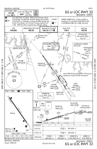
IAC chart of KBBG
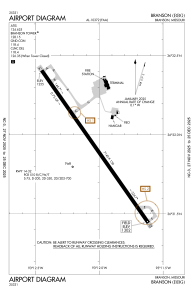
 ADC chart of KBBG
 Satellite view of KBBG
ADC chart of KBBG
Satellite view of KBBG
Sorry, we have no imagery here.
Sorry, we have no imagery here.
Sorry, we have no imagery here.
Sorry, we have no imagery here.
Sorry, we have no imagery here.
Sorry, we have no imagery here.


KBBG - Branson
Located in Branson, United States
ICAO - BBG, IATA -
Data provided by AirmateGeneral information
Coordinates: N36°31'55" W93°12'2"
Elevation is 1302 feet MSL.
Magnetic variation is 02° East View others Airports in Missouri
Operational data
Special qualification required
Current time UTC:
Current local time:
Weather
METAR: KBBG 051345Z 01012KT 1 3/4SM VCTS +RA BKN006 OVC011 07/07 A3004 RMK LTG DSNT ALQDS
Communications frequencies: [VIEW]
Runways:
| RWY identifier | QFU | Length (ft) | Width (ft) | Surface | LDA (ft) |
| 14 | 145° | 7140 | 150 | CONC | 7140 |
| 32 | 325° | 7140 | 150 | CONC | 7140 |
Airport contact information
Address: Branson United States
Satellite view of KBBG
Sorry, we have no imagery here.
Sorry, we have no imagery here.
Sorry, we have no imagery here.
Sorry, we have no imagery here.
Sorry, we have no imagery here.
Sorry, we have no imagery here.