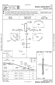
IAC chart of KBBD
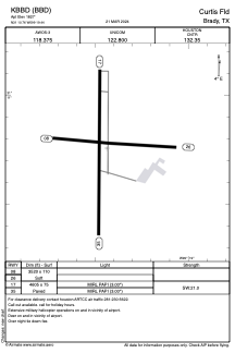
 ADC chart of KBBD
 Satellite view of KBBD
ADC chart of KBBD
Satellite view of KBBD
Sorry, we have no imagery here.
Sorry, we have no imagery here.
Sorry, we have no imagery here.
Sorry, we have no imagery here.
Sorry, we have no imagery here.
Sorry, we have no imagery here.


KBBD - Curtis Fld
Located in Brady, United States
ICAO - BBD, IATA - BBD
Data provided by AirmateGeneral information
Coordinates: N31°10'45" W99°19'26"
Elevation is 1827 feet MSL.
Magnetic variation is 07° East View others Airports in Texas
Operational data
Special qualification required
Current time UTC:
Current local time:
Weather
METAR: KBBD 012115Z AUTO 17012G22KT 10SM CLR 32/11 A2953 RMK AO2
TAF: KBBD 011740Z 0118/0218 18018G26KT P6SM FEW250 FM020800 19013G23KT P6SM BKN015 FM021000 22009KT P6SM BKN015 FM021500 34009KT P6SM SKC
Communications frequencies: [VIEW]
Runways:
| RWY identifier | QFU | Length (ft) | Width (ft) | Surface | LDA (ft) |
| 08 | 93° | 3520 | 110 | GRASS | |
| 26 | 273° | 3520 | 110 | GRASS | |
| 17 | 180° | 4605 | 75 | ASPH | |
| 35 | 0° | 4605 | 75 | ASPH |
Airport contact information
Address: Brady United States
Other aviation service providers
Flight schools

Satellite view of KBBD
Sorry, we have no imagery here.
Sorry, we have no imagery here.
Sorry, we have no imagery here.
Sorry, we have no imagery here.
Sorry, we have no imagery here.
Sorry, we have no imagery here.