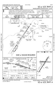
IAC chart of KAVP
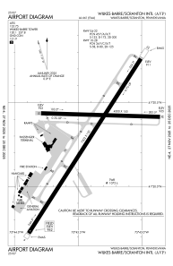
 ADC chart of KAVP
 Satellite view of KAVP
ADC chart of KAVP
Satellite view of KAVP
Sorry, we have no imagery here.
Sorry, we have no imagery here.
Sorry, we have no imagery here.
Sorry, we have no imagery here.
Sorry, we have no imagery here.
Sorry, we have no imagery here.


KAVP - Wilkes-Barre/Scranton Intl
Located in Wilkes-Barre/Scranton, United States
ICAO - AVP, IATA - AVP
Data provided by AirmateGeneral information
Coordinates: N41°20'18" W75°43'24"
Elevation is 961 feet MSL.
Magnetic variation is -11° East View others Airports in Pennsylvania
Operational data
Special qualification required
Current time UTC:
Current local time:
Weather
METAR: KAVP 070154Z 36006KT 10SM OVC055 06/M04 A2994 RMK AO2 PRESRR SLP142 T00561039
TAF: KAVP 062320Z 0700/0724 33004KT P6SM BKN060 FM070700 VRB03KT 3SM -SHRASN BR OVC015 TEMPO 0709/0713 2SM -SHSN BR FM071300 02004KT 5SM -SHRASN BR OVC025 FM071700 32005KT P6SM BKN025 FM072300 25005KT P6SM SCT035
Communications frequencies: [VIEW]
Runways:
| RWY identifier | QFU | Length (ft) | Width (ft) | Surface | LDA (ft) |
| 04 | 33° | 7502 | 150 | ASPH | 7502 |
| 22 | 213° | 7502 | 150 | ASPH | 7502 |
| 10 | 92° | 4300 | 150 | ASPH | 4300 |
| 28 | 272° | 4300 | 150 | ASPH | 4300 |
Airport contact information
Address: Wilkes-Barre/Scranton United States
Other aviation service providers
Flight schools

Aviation Technologies, Inc.
Aviation Technologies, Inc.
cphebus@aviation-technologies.com+1(570)457-4485
Satellite view of KAVP
Sorry, we have no imagery here.
Sorry, we have no imagery here.
Sorry, we have no imagery here.
Sorry, we have no imagery here.
Sorry, we have no imagery here.
Sorry, we have no imagery here.