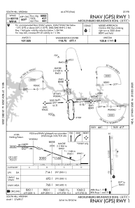
IAC chart of KAVC
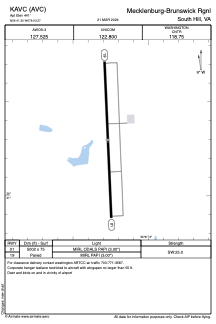
 ADC chart of KAVC
 Satellite view of KAVC
ADC chart of KAVC
Satellite view of KAVC
Sorry, we have no imagery here.
Sorry, we have no imagery here.
Sorry, we have no imagery here.
Sorry, we have no imagery here.
Sorry, we have no imagery here.
Sorry, we have no imagery here.


KAVC - Mecklenburg-Brunswick Rgnl
Located in South Hill, United States
ICAO - AVC, IATA -
Data provided by AirmateGeneral information
Coordinates: N36°41'18" W78°3'16"
Elevation is 441 feet MSL.
Magnetic variation is -09° East View others Airports in Virginia
Operational data
Special qualification required
Current time UTC:
Current local time:
Weather
METAR: KAVC 010235Z AUTO 20006KT 7SM OVC003 18/18 A2974 RMK AO2 LTG DSNT E T01820180
Communications frequencies: [VIEW]
Runways:
| RWY identifier | QFU | Length (ft) | Width (ft) | Surface | LDA (ft) |
| 01 | 358° | 5002 | 75 | ASPH | |
| 19 | 178° | 5002 | 75 | ASPH |
Airport contact information
Address: South Hill United States
Satellite view of KAVC
Sorry, we have no imagery here.
Sorry, we have no imagery here.
Sorry, we have no imagery here.
Sorry, we have no imagery here.
Sorry, we have no imagery here.
Sorry, we have no imagery here.