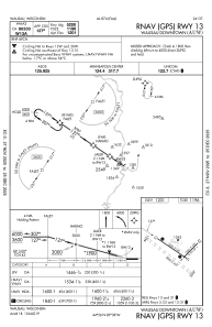
IAC chart of KAUW
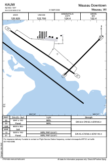
 ADC chart of KAUW
 Satellite view of KAUW
ADC chart of KAUW
Satellite view of KAUW
Sorry, we have no imagery here.
Sorry, we have no imagery here.
Sorry, we have no imagery here.
Sorry, we have no imagery here.
Sorry, we have no imagery here.


KAUW - Wausau Downtown
Located in Wausau, United States
ICAO - AUW, IATA - AUW
Data provided by AirmateGeneral information
Coordinates: N44°55'35" W89°37'37"
Elevation is 1201 feet MSL.
Magnetic variation is -03° East View others Airports in Wisconsin
Operational data
Special qualification required
Current time UTC:
Current local time:
Weather
METAR: KAUW 230954Z AUTO 32004KT 10SM CLR 03/02 A3005 RMK AO2 SLP187 T00330017 $
TAF: KAUW 230520Z 2306/2406 34005KT P6SM SCT050 FM231400 35008KT P6SM SCT029 TEMPO 2314/2318 BKN030 FM231800 35007KT P6SM SCT045 FM240400 01004KT P6SM SCT060
Communications frequencies: [VIEW]
Runways:
| RWY identifier | QFU | Length (ft) | Width (ft) | Surface | LDA (ft) |
| 05 | 44° | 3041 | 100 | ASPH | |
| 23 | 224° | 3041 | 100 | ASPH | |
| 12W | 0° | 8000 | 300 | WATER | |
| 30W | 0° | 8000 | 300 | WATER | |
| 13 | 124° | 5200 | 100 | ASPH | |
| 31 | 304° | 5200 | 100 | ASPH |
Airport contact information
Address: Wausau United States
Other aviation service providers
Flight schools

Satellite view of KAUW
Sorry, we have no imagery here.
Sorry, we have no imagery here.
Sorry, we have no imagery here.
Sorry, we have no imagery here.
Sorry, we have no imagery here.