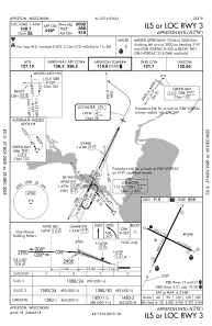
IAC chart of KATW
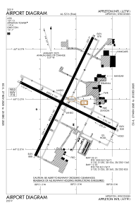
 ADC chart of KATW
 Satellite view of KATW
ADC chart of KATW
Satellite view of KATW
Sorry, we have no imagery here.
Sorry, we have no imagery here.
Sorry, we have no imagery here.
Sorry, we have no imagery here.
Sorry, we have no imagery here.
Sorry, we have no imagery here.


KATW - Appleton Intl
Located in Appleton, United States
ICAO - ATW, IATA - ATW
Data provided by AirmateGeneral information
Coordinates: N44°15'29" W88°31'9"
Elevation is 918 feet MSL.
Magnetic variation is -02° East View others Airports in Wisconsin
Operational data
Special qualification required
Current time UTC:
Current local time:
Weather
METAR: KATW 290855Z AUTO 32006KT 10SM OVC070 13/11 A3005 RMK AO2
TAF: KATW 290520Z 2906/3006 34004KT P6SM OVC050 FM291500 35005KT P6SM BKN060 FM292200 26005KT P6SM SCT120
Communications frequencies: [VIEW]
Runways:
| RWY identifier | QFU | Length (ft) | Width (ft) | Surface | LDA (ft) |
| 03 | 26° | 8003 | 150 | CONC | 8002 |
| 21 | 206° | 8003 | 150 | CONC | 8002 |
| 12 | 116° | 6502 | 150 | CONC | 6501 |
| 30 | 296° | 6502 | 150 | CONC | 6501 |
Airport contact information
Address: Appleton United States
Other aviation service providers
Repair station

Flight schools

Satellite view of KATW
Sorry, we have no imagery here.
Sorry, we have no imagery here.
Sorry, we have no imagery here.
Sorry, we have no imagery here.
Sorry, we have no imagery here.
Sorry, we have no imagery here.