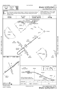
IAC chart of KATA
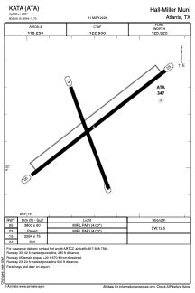
 ADC chart of KATA
 Satellite view of KATA
ADC chart of KATA
Satellite view of KATA
Sorry, we have no imagery here.
Sorry, we have no imagery here.
Sorry, we have no imagery here.
Sorry, we have no imagery here.
Sorry, we have no imagery here.
Sorry, we have no imagery here.


KATA - Hall-Miller Muni
Located in Atlanta, United States
ICAO - ATA, IATA -
Data provided by AirmateGeneral information
Coordinates: N33°6'9" W94°11'42"
Elevation is 280 feet MSL.
Magnetic variation is 04° East View others Airports in Texas
Operational data
Special qualification required
Current time UTC:
Current local time:
Weather at : KTXK - Texarkana Rgnl-Webb Fld ( 43 km )
METAR: KTXK 021153Z 17014G24KT 10SM OVC035 24/20 A2956 RMK AO2 SLP006 T02390200 10244 20233 56009
TAF: KTXK 021140Z 0212/0312 18012G22KT P6SM VCSH OVC030 FM021800 19020G26KT P6SM VCTS OVC050CB FM022000 21014KT P6SM -TSRA OVC050CB FM030000 18006KT 6SM -SHRA VCTS OVC025CB FM030600 17004KT 4SM BR OVC015
Communications frequencies: [VIEW]
Runways:
| RWY identifier | QFU | Length (ft) | Width (ft) | Surface | LDA (ft) |
| 05 | 52° | 3800 | 60 | ASPH | |
| 23 | 232° | 3800 | 60 | ASPH | |
| 15 | 160° | 2264 | 75 | GRASS | |
| 33 | 340° | 2264 | 75 | GRASS |
Airport contact information
Address: Atlanta United States
Satellite view of KATA
Sorry, we have no imagery here.
Sorry, we have no imagery here.
Sorry, we have no imagery here.
Sorry, we have no imagery here.
Sorry, we have no imagery here.
Sorry, we have no imagery here.