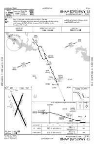
IAC chart of KASL
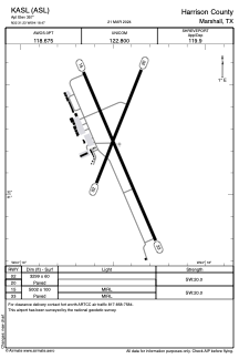
 ADC chart of KASL
 Satellite view of KASL
ADC chart of KASL
Satellite view of KASL
Sorry, we have no imagery here.
Sorry, we have no imagery here.
Sorry, we have no imagery here.
Sorry, we have no imagery here.
Sorry, we have no imagery here.
Sorry, we have no imagery here.


KASL - Harrison County
Located in Marshall, United States
ICAO - ASL, IATA - ASL
Data provided by AirmateGeneral information
Coordinates: N32°31'14" W94°18'28"
Elevation is 357 feet MSL.
Magnetic variation is 03° East View others Airports in Texas
Operational data
Special qualification required
Current time UTC:
Current local time:
Weather
METAR: KASL 011955Z AUTO 16007KT 9SM SCT028 SCT340 24/19 A2973 RMK AO2 PRESFR T02420191
Communications frequencies: [VIEW]
Runways:
| RWY identifier | QFU | Length (ft) | Width (ft) | Surface | LDA (ft) |
| 02 | 22° | 3299 | 60 | ASPH | |
| 20 | 202° | 3299 | 60 | ASPH | |
| 15 | 157° | 5002 | 100 | ASPH | |
| 33 | 337° | 5002 | 100 | ASPH |
Airport contact information
Address: Marshall United States
Satellite view of KASL
Sorry, we have no imagery here.
Sorry, we have no imagery here.
Sorry, we have no imagery here.
Sorry, we have no imagery here.
Sorry, we have no imagery here.
Sorry, we have no imagery here.