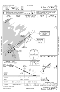
IAC chart of KART
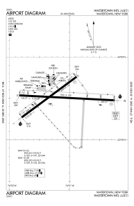
 ADC chart of KART
 Satellite view of KART
ADC chart of KART
Satellite view of KART
Sorry, we have no imagery here.
Sorry, we have no imagery here.
Sorry, we have no imagery here.
Sorry, we have no imagery here.
Sorry, we have no imagery here.
Sorry, we have no imagery here.


KART - Watertown Intl
Located in Watertown, United States
ICAO - ART, IATA - ART
Data provided by AirmateGeneral information
Coordinates: N43°59'31" W76°1'10"
Elevation is 330 feet MSL.
Magnetic variation is -12° East View others Airports in New York
Operational data
Special qualification required
Current time UTC:
Current local time:
Weather
METAR: KART 071156Z AUTO 20004KT 10SM CLR 02/M03 A2987 RMK AO2 SLP119 T00171028 10017 20000 55000 $
TAF: KART 071120Z 0712/0812 17004KT P6SM SCT200 FM071500 23006KT P6SM SCT250 FM072000 24008KT P6SM BKN070 FM080000 21006KT P6SM OVC040 PROB30 0800/0802 4SM -SHRASN OVC025 FM080200 23015G25KT 2SM -SN OVC015 FM080500 24018G28KT P6SM OVC015 FM080800 25018G28KT 2SM -SN OVC025
Communications frequencies: [VIEW]
Runways:
| RWY identifier | QFU | Length (ft) | Width (ft) | Surface | LDA (ft) |
| 07 | 53° | 4999 | 150 | ASPH | 4784 |
| 25 | 233° | 4999 | 150 | ASPH | 4999 |
| 10 | 93° | 7001 | 150 | ASPH | 7001 |
| 28 | 273° | 7001 | 150 | ASPH | 7001 |
Airport contact information
Address: Watertown United States
Other aviation service providers
Flight schools

Satellite view of KART
Sorry, we have no imagery here.
Sorry, we have no imagery here.
Sorry, we have no imagery here.
Sorry, we have no imagery here.
Sorry, we have no imagery here.
Sorry, we have no imagery here.