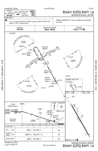
IAC chart of KARM
 ADC chart of KARM
 Satellite view of KARM
ADC chart of KARM
Satellite view of KARM
Sorry, we have no imagery here.
Sorry, we have no imagery here.
Sorry, we have no imagery here.
Sorry, we have no imagery here.
Sorry, we have no imagery here.
Sorry, we have no imagery here.


KARM - Wharton Rgnl
Located in Wharton, United States
ICAO - ARM, IATA - WHT
Data provided by AirmateGeneral information
Coordinates: N29°15'15" W96°9'16"
Elevation is 100 feet MSL.
Magnetic variation is 03° East View others Airports in Texas
Operational data
Special qualification required
Current time UTC:
Current local time:
Weather
METAR: KARM 020415Z AUTO 15015KT 10SM OVC012 24/22 A2965 RMK AO2 T02350220 TSNO
Communications frequencies: [VIEW]
Runways:
| RWY identifier | QFU | Length (ft) | Width (ft) | Surface | LDA (ft) |
| 14 | 151° | 5004 | 75 | ASPH | |
| 32 | 331° | 5004 | 75 | ASPH |
Airport contact information
Address: Wharton United States
Satellite view of KARM
Sorry, we have no imagery here.
Sorry, we have no imagery here.
Sorry, we have no imagery here.
Sorry, we have no imagery here.
Sorry, we have no imagery here.
Sorry, we have no imagery here.