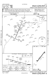
IAC chart of KAPT
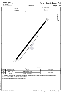
 ADC chart of KAPT
 Satellite view of KAPT
ADC chart of KAPT
Satellite view of KAPT
Sorry, we have no imagery here.
Sorry, we have no imagery here.
Sorry, we have no imagery here.
Sorry, we have no imagery here.
Sorry, we have no imagery here.
Sorry, we have no imagery here.


KAPT - Marion County/Brown Fld
Located in Jasper, United States
ICAO - APT, IATA - APT
Data provided by AirmateGeneral information
Coordinates: N35°3'38" W85°35'7"
Elevation is 641 feet MSL.
Magnetic variation is -02° East View others Airports in Tennessee
Operational data
Special qualification required
Current time UTC:
Current local time:
Weather at : KCHA - Lovell Fld ( 35 km )
METAR: KCHA 071653Z 32009KT 10SM OVC020 13/09 A2980 RMK AO2 SLP085 T01330089
TAF: KCHA 071257Z 0713/0812 32007KT P6SM OVC025 TEMPO 0713/0717 BKN015 FM072000 34009KT P6SM BKN035
Communications frequencies: [VIEW]
Runways:
| RWY identifier | QFU | Length (ft) | Width (ft) | Surface | LDA (ft) |
| 04 | 38° | 3498 | 75 | ASPH | |
| 22 | 218° | 3498 | 75 | ASPH |
Airport contact information
Address: Jasper United States
Satellite view of KAPT
Sorry, we have no imagery here.
Sorry, we have no imagery here.
Sorry, we have no imagery here.
Sorry, we have no imagery here.
Sorry, we have no imagery here.
Sorry, we have no imagery here.