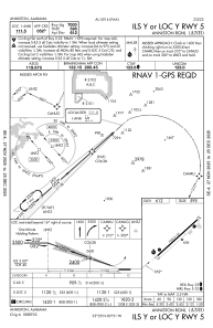
IAC chart of KANB
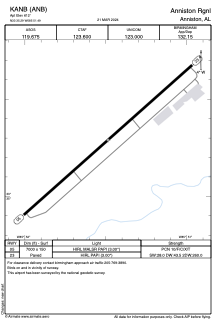
 ADC chart of KANB
 Satellite view of KANB
ADC chart of KANB
Satellite view of KANB
Sorry, we have no imagery here.
Sorry, we have no imagery here.
Sorry, we have no imagery here.
Sorry, we have no imagery here.
Sorry, we have no imagery here.
Sorry, we have no imagery here.


KANB - Anniston Rgnl
Located in Anniston, United States
ICAO - ANB, IATA - ANB
Data provided by AirmateGeneral information
Coordinates: N33°35'17" W85°51'29"
Elevation is 612 feet MSL.
Magnetic variation is -04° East View others Airports in Alabama
Operational data
Special qualification required
Current time UTC:
Current local time:
Weather
METAR: KANB 051353Z AUTO VRB03KT 10SM BKN018 OVC024 23/19 A3013 RMK AO2 SLP196 T02280189
TAF: KANB 051120Z 0512/0612 16007KT P6SM BKN050 TEMPO 0512/0515 BKN015 FM051500 18012G20KT P6SM SCT025 FM051700 19012G23KT P6SM SCT045 FM060300 19010G21KT P6SM BKN025 FM060900 18013G24KT P6SM VCSH BKN015
Communications frequencies: [VIEW]
Runways:
| RWY identifier | QFU | Length (ft) | Width (ft) | Surface | LDA (ft) |
| 05 | 48° | 7000 | 150 | ASPH | |
| 23 | 228° | 7000 | 150 | ASPH |
Airport contact information
Address: Anniston United States
Other aviation service providers
Flight schools

Satellite view of KANB
Sorry, we have no imagery here.
Sorry, we have no imagery here.
Sorry, we have no imagery here.
Sorry, we have no imagery here.
Sorry, we have no imagery here.
Sorry, we have no imagery here.