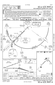
IAC chart of KAMA
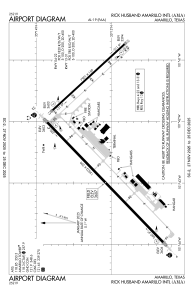
 ADC chart of KAMA
 Satellite view of KAMA
ADC chart of KAMA
Satellite view of KAMA
Sorry, we have no imagery here.
Sorry, we have no imagery here.
Sorry, we have no imagery here.
Sorry, we have no imagery here.
Sorry, we have no imagery here.
Sorry, we have no imagery here.


KAMA - Rick Husband Amarillo Intl
Located in Amarillo, United States
ICAO - AMA, IATA - AMA
Data provided by AirmateGeneral information
Coordinates: N35°13'10" W101°42'21"
Elevation is 3606 feet MSL.
Magnetic variation is 08° East View others Airports in Texas
Operational data
Special qualification required
Current time UTC:
Current local time:
Weather
METAR: KAMA 021053Z 28018G25KT 10SM SCT100 10/M10 A2956 RMK AO2 PK WND 29026/0956 SLP965 T01001100 $
TAF: KAMA 020540Z 0206/0306 29019G32KT P6SM VCSH BKN110 FM020800 28017KT P6SM SCT250 FM022000 25014G22KT P6SM SCT100 FM030300 20010KT P6SM BKN130
Communications frequencies: [VIEW]
Runways:
| RWY identifier | QFU | Length (ft) | Width (ft) | Surface | LDA (ft) |
| 04 | 46° | 13502 | 200 | CONC | 13502 |
| 22 | 226° | 13502 | 200 | CONC | 13502 |
| 13 | 137° | 7901 | 150 | CONC | 7901 |
| 31 | 317° | 7901 | 150 | CONC | 7901 |
Airport contact information
Address: Amarillo United States
Other aviation service providers
Flight schools

Satellite view of KAMA
Sorry, we have no imagery here.
Sorry, we have no imagery here.
Sorry, we have no imagery here.
Sorry, we have no imagery here.
Sorry, we have no imagery here.
Sorry, we have no imagery here.