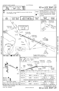
IAC chart of KALN
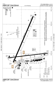
 ADC chart of KALN
 Satellite view of KALN
ADC chart of KALN
Satellite view of KALN
Sorry, we have no imagery here.
Sorry, we have no imagery here.
Sorry, we have no imagery here.
Sorry, we have no imagery here.
Sorry, we have no imagery here.
Sorry, we have no imagery here.


KALN - St Louis Rgnl
Located in Alton/St Louis, United States
ICAO - ALN, IATA - ALN
Data provided by AirmateGeneral information
Coordinates: N38°53'24" W90°2'46"
Elevation is 543 feet MSL.
Magnetic variation is -01° East View others Airports in Illinois
Operational data
Special qualification required
Current time UTC:
Current local time:
Weather
METAR: KALN 082050Z 17006KT 10SM CLR 09/M04 A3018
Communications frequencies: [VIEW]
Runways:
| RWY identifier | QFU | Length (ft) | Width (ft) | Surface | LDA (ft) |
| 11 | 113° | 8099 | 150 | ASPH | 8099 |
| 29 | 293° | 8099 | 150 | ASPH | 8099 |
| 17 | 173° | 6500 | 100 | ASPH | |
| 35 | 353° | 6500 | 100 | ASPH |
Airport contact information
Address: Alton/St Louis United States
Other aviation service providers
Repair station

Satellite view of KALN
Sorry, we have no imagery here.
Sorry, we have no imagery here.
Sorry, we have no imagery here.
Sorry, we have no imagery here.
Sorry, we have no imagery here.
Sorry, we have no imagery here.