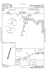
IAC chart of KAKQ
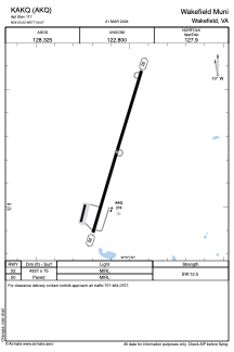
 ADC chart of KAKQ
 Satellite view of KAKQ
ADC chart of KAKQ
Satellite view of KAKQ
Sorry, we have no imagery here.
Sorry, we have no imagery here.
Sorry, we have no imagery here.
Sorry, we have no imagery here.
Sorry, we have no imagery here.
Sorry, we have no imagery here.


KAKQ - Wakefield Muni
Located in Wakefield, United States
ICAO - AKQ, IATA -
Data provided by AirmateGeneral information
Coordinates: N36°59'14" W77°0'4"
Elevation is 111 feet MSL.
Magnetic variation is -11° East View others Airports in Virginia
Operational data
Special qualification required
Current time UTC:
Current local time:
Weather
METAR: KAKQ 011554Z AUTO VRB04KT 10SM CLR 14/03 A3003 RMK AO2 SLP171 T01390028
Communications frequencies: [VIEW]
Runways:
| RWY identifier | QFU | Length (ft) | Width (ft) | Surface | LDA (ft) |
| 02 | 17° | 4337 | 75 | ASPH | |
| 20 | 197° | 4337 | 75 | ASPH |
Airport contact information
Address: Wakefield United States
Satellite view of KAKQ
Sorry, we have no imagery here.
Sorry, we have no imagery here.
Sorry, we have no imagery here.
Sorry, we have no imagery here.
Sorry, we have no imagery here.
Sorry, we have no imagery here.